Loading... Please wait...
- Home
- Raspberry Pi
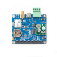
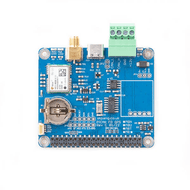
- PiCAN FD with GPS/GNSS ublox NEO-M8M for Raspberry Pi


)

Product Description
Free Shipping Within the United States!
The PiCAN FD board has a ublox NEO-M8M GPS/GNSS receiver. The NEO-M8 modules employ simultaneous reception of up to three GNSS systems (GPS/Galileo together with BeiDou or GLONASS), recognize multiple constellations simultaneously, and provide outstanding positioning accuracy even when weak signals are involved. The antenna connection is via an SMA connector.
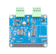
The onboard Microchip MCP2518FD IC provides classic CAN and CAN FD.
There is an easy-to-install SocketCAN driver and programming support in C or Python.
Dimensions

The. board height is 12mm.
CAN FD Features
- Microchip MCP2518FD CAN Controller
- Arbitration Bit Rate u pto 1Mbps
- Data Bit Rate upto 8Mbps
- CAN FD Controller modes
- Mixed CAN 2.0B and CANFD mode
- CAN 2.0B mode
- High speed SPI Interface (10 MHz)
- 120Ω terminator ready
- LED indicator (GPIO04)
- Four fixing holes, comply with Pi Hat standard
- SocketCAN driver, appears as can0 to application
- Interrupt RX on GPIO25
- Fix status LED
NEO-M8M Features
- 72-channel u-blox M8 engine GPS/QZSS L1 C/A, GLONASS L10F, BeiDou B1 SBAS L1 C/A: WAAS, EGNOS, MSAS Galileo-ready E1B/C
- USB-C, I2C and UART communication
- SMA antenna connection
- u-center software compatible. Requires Windows PC via USB-C
- Time Pulse LED
Optional Items
A GPS Antenna is not included in the scope of delivery. Please see our recommendation below:
Documents

Programming GPS and OpenStreetMap Applications with Java
Written by an expert in developing GPS systems with digital maps and navigation, Programming GPS and OpenStreetMap Applications with Java: The RealObject Application Framework provides a concrete paradigm for object-oriented modeling and programming. It presents a thorough introduction to the use of available global positioning data for developing applications involving digital maps.
The author first describes the different formats of GPS data and digital maps and shows how to use recorded GPS traces to replay and display this data on a digital map. Then, he works through the processing steps of obtaining dedicated data from OpenStreetMaps and how to extract a network for a simple navigation application. For each topic covered―GPS data, OpenStreetMaps, and navigation―Java code is developed that can easily be adapted to the readers’ needs and locality.
Finally, all components are put together in a sample computer game application modeled on the well-known board game Scotland Yard. The computer game is intended to be a basis for readers to develop and customize their applications for their desired geographical area. The developed application can be "published" on the Internet and made available for interactive multiplayer competition.